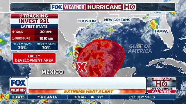
And all eyes are on the southern Gulf tonight. Invest 92L is now up to a high chance of tropical development. A tropical depression could form during the second half of the work week with the potential to bring heavy rain and flooding to the Gulf Coast this weekend. Joining us now to help break down what's ahead is Jamie Rhome, the Deputy Director of the National Hurricane Center. Jamie, we are always so lucky to have you on. At this stage, we are, you know, multiple days removed from this, but after a fairly lackluster hurricane season, what should folks be maybe prepping for along the Gulf Coast? You know, if I were a resident of the northern or northeastern Gulf Coast, I would be looking at my hurricane supplies. I mean, let's be realistic. A lot of people probably procrastinated this year in terms of preparedness, and if you're one of those folks, now's a good time to go ahead and finish up your hurricane readiness because regardless of whether this system forms into a named system or not, it is going to spread really heavy rainfall and potential flooding over portions of the northeast Gulf Coast later this week. And Jamie, realistically, what are the chances this has of becoming a hurricane? Because we haven't had one in over 330 or so days. This is really the best chance that we have and maybe the last run at tropical development in the Atlantic this season. Yeah, I mean, we have this in the high category of formation, and that's generally reserved for a disturbance that we think has a greater than 60% chance of developing into a tropical depression or tropical storm. And in this case, the chances of development over the next week is 80%. So four out of five times a system like this in this situation would in fact go on to develop to a tropical depression or tropical storm. But regardless of that, I would say the potential for rainfall, heavy rainfall and flooding along the path of this eventual disturbance is even higher than that, potentially, you know, 90 or 100% later in the week and over the weekend. And the rainy conditions right now from this front, not making it any easier. You're already looking at the antecedent wet conditions, you add on additional tropical moisture, you don't get much of a break. So yes, that flash flood threat is something that even given the level of uncertainty we may have at this point in time with the forecast for Invest 92L, that's the one thing with certain we can say that heavy rain is going to be a problem. But the setup for this is interesting moving forward. The jet dynamics are going to play a key role, both positively and also negatively in that formation. Can you dive a little bit deeper into that? Well, you kind of alluded to it with the discussion of the cold front. It's kind of a cold front sort of draped in here. So everything north of that is unfavorable for a system to develop, and everything south of that is more favorable, generally speaking. And so the system is going to kind of ride along that boundary between unfavorable and favorable conditions. And that's why you see some of the prediction models are a little bit spread apart in terms of what they think the eventual outcome of this particular system will be. But that's also why we're so confident that the heavy rains are going to be there because all of this tropical moisture you see in satellite imagery is going to ride right along that boundary, and in many cases, it's already raining. So high confidence in a heavy rain event. It remains to be seen with this sort of scenario that I unpacked for you, just how strong of development the system could undergo over the next several days. So what exactly are you and your team looking at that are key signals that will determine eventually where the system moves, given the uncertainty we have right now? So the timing is a really big factor, and if you've been paying attention, the timing was a little bit quicker today in the models. That quickness changes the environment that the system could ultimately be moving through. If that speed, that forward speed materializes, it'd be a slightly more favorable area of development, and that's sort of why you saw us ramp up the forecast and messaging today. If that forward speed, if it sort of comes out of this area quicker, it'll have a little bit better chance of developing and possibly a little bit stronger of a system. If it's a little bit more sluggish and sort of languishes down here a little longer, that's going to tend to inhibit it from developing as robust if the system sort of ejects out of here really quickly. It's the Gulf of America, relatively untouched so far this hurricane season, so we've got a lot of warm water to work with. So this is the storm to watch moving forward. Jamie Rhome, National Hurricane Center Deputy Director, thanks so much for joining us and sharing some of the insight behind y'all's decision making today. Thank you.